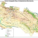
Dedoplistskaro Municipality
Area – 2529.2 sq. km.
Population – 21,1 thousand people
Distance from Tbilisi – 130-140 km.
Details – Dedoplis Tskaro
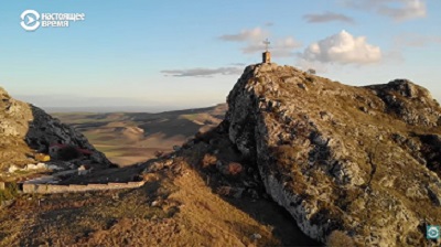
Dedoplistskaro Municipality is located in the southern-easternmost part of Georgia, Kakheti region, Iori Plateau, at the border of Georgia and Azerbaijan, between Iori and Alazani rivers. The climate is continental. Most part of the territory is occupied by fertile agricultural lands – tillable lands and pastures, therefore, field husbandry and cattle breeding (including, sheep farming), as well as viticulture are well developed here.
Wheat, sunflower, barley, maize, vegetables and melons, and grapevines are grown in Dedoplistskaro Municipality; Cattle breeding is also developed. High-quality wheat flour, wine, meat, milk and dairy products, eggs, honey, etc. are produced in this region. There are deposits of limestone, oil, and clay.
The population of Dedoplistskaro Municipality is diverse: Mtiulians, Pshavians, Khevsurians, and Mokhevians resettled from the mountains to the plains by the mediation of Vazha Pshavela in the 19th century and reside here next to Kizikians. You will find densely populated Rachvelians in the village Mirzaani, Heretians, and eco-migrants from Adjaria in the villages Pirosmani and Samtatskaro. Local Russians, Armenians, and other nationalities consider Dedoplistskaro as their homeland.
The ethnic-national diversity of the Municipality influences the local traditions and lifestyle, cuisine, and hospitability – the visitors can taste Kakhetian wine and Chacha, Kizikian Nazuki (pastry), Dedas Puri (bread), Nettle Pkhali (chopped Nettle leaves), beans cooked in a Kizikian style, Mtiulian and Khevsurian Khinkali (dumpling), Adjarian Khachapuri (cheese-filled bread), Achma (type of Khachapuri) etc.